Introduction
The Hueco Bolson is a thick pocket of sediments derived from nearby mountains
that
extends from New Mexico, through Texas, and into Mexico in the El Paso and
Ciudad
Juarez area. Over time, these sediments filled with water and became the Hueco
Bolson
aquifer: an oasis of plentiful water in the northern part of the Chihuahuan
Desert. El Paso
and Ciudad Juarez have relied on the Hueco Bolson aquifer as a primary source of
drinking water for several decades (Sayre and Penn, 1945; White and others,
1997).
Ciudad Juarez, several communities in New Mexico, and the Fort Bliss Military
Reservation currently depend on the Hueco Bolson aquifer as their sole source of
drinking water (Sheng and others, 2001). Because of the desert climate and the
local
geology, the aquifer is not easily replenished, and recharge is low. Low
recharge and high
pumping rates have caused large water-level declines and large decreases in
fresh-water
volumes in the aquifer.
The aquifer and the El Paso-Ciudad Juarez area are at the crossroads. With
current trends,
groundwater models predict that El Paso will pump the last of its fresh water by
2025,
and Ciudad Juarez will pump the last of its fresh water by 2005 (Sheng and
others, 2001).
The El Paso Water Utilities/Public Service Board (EPWU) has recognized the
nature of
limited groundwater resources in the area and has investigated and invested in
several
strategies to increase the longevity and usefulness of the aquifer. The purpose
of this
paper is to briefly summarize the hydrogeology of the Hueco Bolson aquifer and
discuss
several of the management strategies to protect and responsibly use the aquifer.
Hydrogeology
The Hueco Bolson aquifer is coincident with the Hueco Bolson, a long,
sediment-filled
trough that lies between the Franklin, Organ, and San Andres Mountain ranges and
the
Quitman, Malone, Finlay, Hueco, and Sacramento Mountain ranges (fig. 6-1). Hill
(1900)
defined the Hueco Bolson as including the Tularosa Basin (as shown in fig. 6-1).
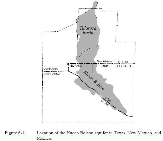
However, Richardson (1909) divided the bolson into two parts: the Tularosa Basin
to the
north and the Hueco Bolson to the south. The topographic divide between these
two
basins is about 7 mi north of the Texas New Mexico border. However, the Hueco
Bolson
and the Tularosa Basin are hydraulically connected to each other (Wilkins, 1986)
and
have been combined into the Hueco-Tularosa aquifer (Hibbs and others, 1997).
The Hueco Bolson is about 200 mi long and 25 mi wide. The Hueco Bolson aquifer
consists of unconsolidated to slightly consolidated deposits composed of fine-
to
medium-grained sand with interbedded lenses of clay, silt, gravel, and caliche.
Sediments
in the bolson are fluvial, evaporitic, alluvial fan, and aeolian in origin and
have a
maximum thickness of 9,000 ft (Mattick, 1967; Cliett, 1969; Abeyta and Thomas,
1996).
The bottom part of the Hueco Bolson is primarily clay and silt. Therefore, only
the top
several hundred feet produce good-quality water.
Recharge
The Hueco Bolson aquifer is recharged by mountain-front recharge; seepage from
the Rio
Grande, canals, and agricultural drains; and deep-well injection (Knorr and
Cliett, 1985;
Land and Armstrong, 1985; White and others, 1997). Mountain-front
recharge is the
seepage of surface run-off after rainfalls into the aquifer where the bolson
laps up against
bordering mountains. Before the aquifer was heavily pumped, water in the aquifer
naturally discharged to the Rio Grande. After pumping caused water levels to
decline, the
Rio Grande began to lose water into the aquifer, so much so that a part of the
river
through El Paso-Ciudad Juarez has been lined with concrete to minimize leakage.
Unlined irrigation canals and drains also leak water into the aquifer, although
the water is
usually of poor quality. EPWU has taken treated wastewater and injected it
up-gradient of
one of El Paso’s well fields to increase recharge to the aquifer.
Meyer (1976) estimated that mountain-front recharge (from the Organ and Franklin
Mountains in New Mexico and Texas and the Sierra de Juarez in Mexico) to the
aquifer
in El Paso County is 5,640 acre-ft/yr. White (1987) estimated that about 33,000
acre-ft/yr
of water is recharged into the Rio Grande alluvium overlying the bolson aquifer.
Recharge from the Rio Grande was reduced significantly when the bottom of the
Rio
Grande was lined in 1973 and 1998 in the El Paso-Ciudad Juarez area (Hibbs and
others,
1997; Heywood and Yager, in review).
Treated wastewater is injected at the Fred Harvey Wastewater Treatment Plant in
El Paso
and provided about 3,800 acre-ft of water per year in 1995 (USEPA, 1995) and
about
1,800 acre-ft in 1999 (Sheng and others, 2001).
Well Yields
Well yields in the Texas part of the Hueco Bolson aquifer are as much as 1,800
gpm
(Hibbs and others, 1997). In New Mexico, yields are higher in alluvial fans that
flank the
basin (~1,400 gpm) and lower in the interior of the basin (300 to 700 gpm) (Hibbs
and
others, 1997). In the well field for Ciudad Juarez in Mexico, yields range
between 300
and 1,500 gpm (Hibbs and others, 1997). Hydraulic conductivity in the Hueco
Bolson, as
determined with 73 aquifer tests, varies from 6.4 to 98.9 ft/day (Hibbs and
others, 1997).
Pumping
The Hueco Bolson aquifer is pumped at a much greater rate than the aquifer is
recharged.
Groundwater withdrawals from the aquifer in Texas amounted to about 69,000
acre-ft in
1999 (Sheng and others, 2001): about nine times greater than the amount of
recharge in
El Paso County. Over the past 20 yr, pumping from the Hueco and Mesilla Bolsons
in
Texas has ranged from 96,000 to 138,000 acre-ft/yr (Mace, this volume).
Water Quality
Water quality in the Hueco Bolson varies depending on location and depth. Water
quality
in the Texas part of the Hueco Bolson tends to be better to the west than to the
east,
although there are pockets of good-quality water in the eastern part of the
bolson (Gates
and others, 1980). North of the Texas-New Mexico border, water tends to have
total
dissolved solids (TDS) greater than 1,000 mg/L except near mountain fronts where
there
is active recharge (Hibbs and others, 1997). The upper part of the aquifer
tends to be
fresher with TDS ranging between 500 and 1,500 mg/L, with an average of about
640
mg/L (Ashworth and Hopkins, 1995). Water quality has been affected by the large
waterlevel
declines in the aquifer, which have induced flow of poor-quality water into
areas of
fresh water. Water quality in the shallow part of the aquifer along the Rio
Grande in the
alluvium has degraded because of leakage of poor-quality irrigation return-flow
into the
aquifer (Sheng and others, 2001). Water quality beneath Ciudad Juarez is
generally less
than 1,000 mg/L TDS (Hibbs and others, 1997), however, water-quality
deterioration has
been observed in wells along the border and in the downtown area.
Water Levels and Groundwater Flow
Depth to water in the Hueco Bolson aquifer ranges from very shallow to very
deep.
Depth to groundwater near the Cities of Tularosa and Alamogordo is between 20
and 150
ft, whereas depth to water below El Paso ranges from 250 to 400 ft in depth, and
depth to
water below Ciudad Juarez ranges between 100 and 250 ft (Hibbs and others,
1997).
Depth to water below the Rio Grande is less than 70 ft. Groundwater flows from
the
Tularosa Basin southward into the Hueco Bolson and into Texas (Hibbs and others,
1997,
their fig. 3.8). Little drawdown has been recorded in the northern part of the
aquifer. The
drawdown in Hueco Bolson along the Texas-New Mexico border has been relatively
small, not exceeding 30 ft (Hibbs and other 1997). In heavily developed parts of
the
Hueco Bolson aquifer, drawdowns since predevelopment in 1903 are up to 170 ft.
Focal
points of drawdown are beneath the City of El Paso and Ciudad Juarez (Hibbs and
others,
1997).
The model by Heywood and Yager (in review) suggests that about 6,000 acre-ft/yr
of
groundwater flowed in the Hueco Bolson aquifer from New Mexico into Texas before
large-scale pumping by El Paso in the 1960’s. Since then, the amount of flow has
increased to about 18,000 acre-ft/yr. In the El Paso-Ciudad Juarez area,
groundwater
flows toward cones of depression. Between 1910 and 1960, groundwater flowed from
Mexico into Texas toward pumping centers in El Paso (Sheng and others, 2001).
Since
1960, groundwater, generally of poor quality, has flowed from Texas into Mexico
(Sheng
and others, 2001).
Groundwater Models
Several groundwater flow models have been constructed for the Hueco Bolson
aquifer
system. These models include an early electric-analog model of the El Paso area
(Leggat
and Davis, 1966) and three numerical models developed by the U.S. Geological
Survey,
including (1) Meyer and Gordon (1973) and Meyer (1975, 1976) (later updated by
Knowles and Alvarez, 1979), (2) Groschen (1994), and (3) an as yet unpublished
model
(Heywood and Yager, in review). Mullican and Senger (1990, 1992) developed a
model
of the southeastern part of the Hueco Bolson. Mexico has also developed a
groundwater
flow model for part of the area. Wilson and others (1986) used a preexisting
model to
predict water resources through 2060.
Models by Groschen (1994) and Heywood and Yager (in review) simulate potential
water-level declines, as well as changes in water quality due to pumping.
Groschen
(1994) showed that water quality in the bolson is most likely affected by
horizontal
movement of saline water in response to pumping.
The integrated flow and water-quality model by Heywood and Yager (in review)
represents the cooperation of EPWU, the USGS, the International Boundary and
Water
Commission (IBWC), Fort Bliss Military Reservation, JMAS (Junta Municipal de
Agua
y Saneamiento de Ciudad Juarez), and CILA (Comision Internacional de Limites y
Aguas). Binational coordination has included the exchange of aquifer information
and
comparison of water-resource management plans. The model is being used to assess
(1)
water storage in the aquifer, (2) the optimization of pumping for fresh and
brackish water,
(3) the location of new production wells, (4) the control of brackish-water
intrusion, (5)
the design of an aquifer storage and recovery program, and (6) the planning of
water
resources among Texas, New Mexico, and Mexico (Sheng and others, 2001).
Groundwater Availability
Groundwater availability represents the amount of water that can be used from an
aquifer.
Groundwater availability can be defined in many different ways depending on the
local
socioeconomic needs (Mace and others, 2001). In the El Paso area, groundwater
availability has been defined using a systematic depletion approach, where the
total
amount of recoverable water is considered the amount of water available for use.
In
general, groundwater availability is assessed for the fresh-water part of the
aquifer.
However, as water resources become scarcer in the state, more and more areas,
including
El Paso, are also evaluating the usable amounts of slightly saline water for
ongoing or
potential desalination projects.
Fresh Water
The approximate volume of recoverable freshwater in the entire Hueco Bolson
aquifer is
about 7.5 million acre-ft, with 3 million acre-ft in Texas, 3.9 million acre-ft
in New
Mexico, and 600,000 acre-ft in Mexico (Sheng and others, 2001, on the basis of a
review
of USGS publications). The Far West Texas Planning Group estimated that there
were
about 3 million acre-ft of fresh water in the Hueco Bolson and 2.5 million
acre-ft of
slightly saline water for desalination (FWTPG, 2001). Recoverable fresh water
accounts
for economic and geologic constraints and does not represent all of the fresh
water in the
aquifer.
Other studies have suggested differing volumes of fresh water. Knowles and
Kennedy
(1956) estimated that the Hueco Bolson in Texas had about 7.4 million acre-ft of
recoverable water, with less than 250 mg/L chloride (~750 mg/L TDS). Meyer
(1976)
estimated the recoverable amount of fresh water in the Texas part of the Hueco
Bolson to
hold 10.64 million acre-ft. White (1987) estimated that the Hueco Bolson aquifer
in
Texas holds about 9.95 million acre-ft of recoverable fresh water. The TWDB
(1997)
estimated that there was about 9 million acre-feet of fresh water in the
Texas part of the
that there was about 9 million acre-feet of fresh water in the Texas part of the
Hueco Bolson.
Slightly Saline Water
Slightly saline water may be a large potential water resource in the El Paso
area. There is
an estimated 20 million acre-ft of slightly saline water (TDS between 1,000 and
3,000
mg/L) in the Hueco Bolson aquifer in El Paso County (Sheng and others, 2001).
Similar
volumes of slightly saline water may also exist in New Mexico and Mexico (Sheng
and
others, 2001). Sheng and others (2001) recommended additional studies to
quantify a
more exact volume of poor-quality water in the aquifer.
Strategies to Increase Groundwater Availability
Although recent modeling work suggests that the Hueco Bolson in the El Paso area
will
run out of fresh water by 2025, it is not a forgone conclusion. For prediction
purposes,
the model assumes that current trends and practices will remain the same.
However, the
life of the fresh groundwater resource can be extended by implementing
strategies to
increase the availability of groundwater.
Increase Surface-Water Use
By increasing the use of surface water, groundwater use can be minimized, thus
extending the useful life of the fresh-water part of the aquifer. In this case,
surface water
is relied upon when plentiful, and groundwater is relied upon when surface water
is not
plentiful. Regional water providers are pursuing this strategy by the
implementation of
the Regional Sustainable Water Project (IBWC and EPWU, 2000). The Far West Texas
Planning Group also identifies the pursuit of additional surface-water supplies
as a
recommended water management strategy for the area (FWTPG, 2001). However, the
planning group noted that El Paso cannot rely on the Rio Grande for water during
times
of severe drought (FWTPG, 2001).
Hydraulic Control and Desalination
To reduce the degradation of groundwater quality due to laterally flowing poorer
quality
water, wells can be installed to hydraulically control the migration of poorer
quality water
by capturing the poorer quality water before it mixes with fresher water. The
produced
water can then be desalinated. EPWU and the Department of Defense at the Fort
Bliss
Military Reservation are investigating this approach in existing wells in the
Airport/Montana well field (Sheng and others, 2001). To maximize the water
supply, the
desalinated water (~200 mg/L TDS) can then be blended with slightly saline water
(~1,500 mg/L TDS) to produce a water with a TDS of about 900 mg/L TDS. Hydraulic
control and desalination extend the life of the fresh-water part of the aquifer
by protecting
existing fresh-water resources from further intrusions of poor-quality water and
decreasing the reliance on the fresh-water part of the aquifer. Hydraulic
control and
desalination are also being considered in other El Paso wellfields (Sheng
and others,
2001).
Pumping Optimization
Pumping of wells can be optimized to minimize the migration of poor-quality
water and
the depth of cones of depression around pumping centers. Pumping of water-supply
wells
should be optimized aquiferwide to minimize the effects of pumping on the
migration of
poor-quality water into areas of fresh water. An operational priority list for
the Hueco
well fields has been developed and used in well-field operation for over a year
(Sheng
and others, 2001). Results of the optimization program will be evaluated to
further
improve operation of the well fields. Pumping optimization extends the life of
the freshwater
resource by minimizing the impacts of poor-quality water intrusions.
Aquifer Storage and Recovery
Aquifer Storage and Recovery (ASR) is when treated surface water is injected
into an
aquifer when it is plentiful and demand is low, and then recovered the stored
water from
the aquifer when demand is high or during times of drought. ASR extends the life
of the
aquifer by maximizing the use of surface water and recharging the aquifer. In
addition, it
will also prevent brackish water intrusion if injection wells are located along
the
transition zone of marginal quality groundwater.
Blending high-grade water with poor-quality water
Using the best quality water first has often been the preferred method of
groundwater
production. However, by blending good quality water with poorer quality water up
to the
Safe Drinking Water Act standards for TDS, chloride, and sulfate secondary
maximum
contamination levels, water providers can enhance their production capacity. The
blending method extends the life of the aquifer by maximizing the use of the
freshwater
resource. When combined with hydraulic control, existing freshwater resources
can also
be additionally protected.
Conclusions
The Hueco Bolson aquifer and the El Paso-Ciudad Juarez area are at the
crossroads.
Several scientific studies and recent modeling projects suggest that, under
current trends,
fresh water from the Hueco Bolson aquifer in Texas will be depleted by 2025.
However,
using groundwater more strategically can extend the longevity of fresh-water
resources in
the aquifer. EPWU and FWTPG are actively researching and implementing a number
of
strategies to do just this, including increased surface-water use, hydraulic
control and
desalination, pumping optimization, aquifer storage and recovery, and blending
to
increase freshwater supplies. The area will need to continue to follow this path
to ensure
that future water needs of El Paso are met.
Acknowledgments
Authors would like to thank Mr. Edmund G. Archuleta, General Manager of EPWU,
and
John Burkstaller, Chief Technical Officer of EPWU, for their valuable
discussions with
the authors. Authors also thank Mr. Charles Heywood of USGS, Jeff Devere of Rio
Blanco County Development Department of Colorado, and Mr. Roger Sperka and Mr.
Scott Reinert of EPWU for their assistance. The opinions and results presented
are those
of the authors and do not represent those of EPWU.
References:
Abeyta, C., and Thomas, C. L., 1996, Hydrogeology and groundwater quality of the
chromic acid pit site, U.S. Army Air Defense Artillery Center and Fort Bliss, El
Paso,
Texas: U.S. Geological Survey Water Resource Investigations Report 96-4035.
Ashworth, J. B., and Hopkins, J., 1995, Aquifers of Texas: Texas Water
Development
Board Report 345, 69 p.
Cliett, T. E., 1969, Groundwater occurrence of the El Paso area and its related
geology: in
New Mexico Geological Society, Border Region, Chihuahua, Mexico, and United
States, Guidebook, 20th Field Conference, p. 209-214.
FWTPG, 2001, Far West Texas Regional Water Plan: Far West Texas Planning Group,
report submitted to the Texas Water Development Board, variously paginated.
Gates, J. S., White, D. E., Stanley, W. D., and Ackermann, H. D., 1980,
Availability of
fresh and slightly saline groundwater in the basins of westernmost Texas: Texas
Department of Water Resources Report 256, 108 p.
Groschen, G. E., 1994, Simulation of ground-water flow and the movement of
saline
water in the Hueco Bolson aquifer, El Paso, Texas, and adjacent areas: U.S.
Geological Survey Open-File Report 92-171.
Heywood, C. E., and Yager, R. M., in review, Ground-water flow and
chloride-transport
simulation of the Hueco Basin, El Paso, Texas, and adjacent areas: U.S.
Geological
Survey.
Hibbs, B. J., Ashworth, J. B., Boghici, R. N., Hayes, M. E., Creel, B. J.,
Hanson, A. T.,
Samani, B. A., and Kennedy, J. F., 1997, Trans-boundary aquifers of the El
Paso/Ciudad Juarez/Las Cruces region: report prepared by the Texas Water
Development Board and New Mexico Water Resources Research Institute for the
U.S. Environmental Protection Agency, Region VI, under contract X 996343-01-0
and X 996350-01-0, 156 p.
Hill, R. T., 1900, Physical geography of the Texas region: U.S. Geological
Survey
Topographic Atlas, Folio No. 3.
IBWC (International Boundary and Water Commission) and EPWU, 2000, Draft
environmental impact statement, El Paso–Las Cruces regional sustainable water
project, volume I
Knorr, D. and Cliett, T., 1985, Proposed groundwater recharge at El Paso, Texas:
in
Asano, T., ed., Artificial recharge of groundwater Butterworth Publishers, p.
425-480.
Knowles, D. B., and Kennedy, R. A., 1956, Groundwater resources of the Hueco
Bolson,
northeast of El Paso, Texas: Texas Board of Water Engineers Bulletin 5615, 265
p.
Knowles, T. R., and Alvarez, H. J., 1979, Simulated effects of ground-water
pumping in
portions of the Hueco Bolson in Texas and Mexico during the period 1973 through
2029: Texas Department of Water Resources Report LP-104.
Land, L. F., and Armstrong, C. A., 1985, A preliminary assessment of
land-surface
subsidence in the El Paso area, Texas: U.S. Geological Survey Water Resource
Investigations Report 85-4155.
Leggat, E. R., and Davis, M. E., 1966, Analog model study of the Hueco bolson
near El
Paso, Texas: Texas Water Development Board, 26 p.
Mace, R. E., Mullican, W. F., III, and Way, T. (S.-C.), 2001, Estimating
groundwater
availability in Texas: in the proceedings of the 1st annual Texas Rural Water
Association and Texas Water Conservation Association Water Law Seminar: Water
Allocation in Texas: The Legal Issues. Austin, Texas, January 25-26, 2001.
Section 1,
16 p.
Mattick, R. E., 1967, A seismic and gravity profile across the Hueco Bolson,
Texas: in
U.S. Geological Survey Professional Paper 575-D, p. 85-91
Meyer, W. R., 1975, Digital model studies of the hydrology of the Hueco Bolson,
El Paso
area, Texas: in Hills, J. M., ed., Exploration from the mountains to the basin,
p. 141.
Meyer, W. R., 1976, Digital model for simulated effects of ground water pumping
in the
Hueco Bolson, El Paso area, Texas, New Mexico, and Mexico: U.S. Geological
Survey Water-Resources Investigations Report 58-75.
Meyer, W. R., and Gordon, J. D., 1973, Water-budget studies of lower Mesilla
Valley
and El Paso Valley, El Paso County, Texas: U.S. Geological Survey, Open-File
Report OF 73-0185, 41 p.
Mullican, W. F., III, and Senger, R. K., 1990, Saturated-zone hydrology of
south-central
Hudspeth County, Texas, in Hydrogeology of Trans-Pecos Texas: Kreitler, C.W.,
and
Sharp, J. .M., Jr., eds., The University of Texas at Austin, Bureau of Economic
Geology Guidebook 25, p. 37-42.
Mullican, W. F., III, and Senger, R. K., 1992, Hydrogeologic investigations of
deep
ground-water flow in the Chihuahuan Desert, Texas: The University of Texas at
Austin, Bureau of Economic Geology, Report of Investigations 205, 60 p.
Richardson, G. B., 1909, Geological atlas, U.S. Geological Survey, El Paso Folio
(No.
166).
Sayre, A. N., and Penn, L., 1945, Groundwater resources of the El Paso area,
Texas: U.S.
Geological Survey Water Supply Paper 919.
Sheng, Z., Fahy, M. P., and Devere, J., 2001, Management strategies for the
Hueco
Bolson in the El Paso, Texas, USA, and Ciudad Juarez, Mexico, region: in
Bridging
the gap Proceedings of the World Water and Environmental Resources Congress,
Orlando, Florida, May 20–24, CD ROM, ASCE.
TWDB, 1997, Water for Texas: Texas Water Development Board, Document No. GP-6-
2, variously paginated.
USEPA , 1995, Hueco Bolson ground water recharge demonstration project, El Paso
Texas, Part II, Water quality analysis: U.S. Environmental Protection Agency.
White, D. E., 1987, Summary of hydrologic information in the El Paso, Texas,
area, with
emphasis on ground-water studies, 1908-1980: Texas Water Development Board
Report 300, 75 p.
White, D. E., Baker, E. T., and Sperka, R., 1997, Hydrology of the shallow
aquifer and
uppermost semi-confined aquifer near El Paso, Texas: U.S. Geological Survey,
Water-Resources Investigations Report 97-4263.
Wilkins, D. W., 1986, Geohydrology of the southwest alluvial basins regional
aquifer systems
analysis, parts of Colorado, New Mexico, and Texas: U.S. Geological
Survey.
Wilson, L., and Associates, 1986, Technical Report for the Hueco Bolson Hearing,
Prepared for El Paso Water Utilities/Public Service Board.